Cloudcompare Plugin
An overview of the CSF_CC interface
Set up of parameters The parameters which need to be set by user can be divided into General parameter and Advanced parameter. The general parameter means that it must be set each time the program runs. The advance parameter means that it can be set according to the users need.
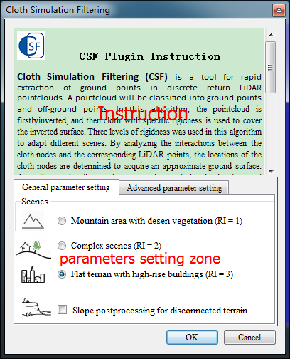
General parameters
※ Scenes
Three options are under this parameter : Mountain area with dense vegetation, complex scenes, and flat terrain with high-rise buildings. This parameter help users to set scenes type of the point clouds. When you set up this parameter, the rigidness will be determined actually. Please refers to the article: An Easy-to-Use Airborne LIDAR Data Filtering Method Based on Cloth Simulation.
※ lope post processing for disconnected terrain
For steep slopes, this algorithm may yield relatively large errors because the simulated cloth is above the steep slopes and does not fit with the ground measurements very well due to the internal constraints among particles. This problem can be solved by selecting this option. If there are no steep slopes in your scenes, just neglect it.
Advanced parameters
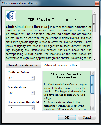
※ Cloth resolution
Cloth resolution refers to the grid size of cloth which is use to cover the terrain. The bigger cloth resolution you have set, the coarser DTM you will get.
※ max iterations
Max iterations refers to the maximum iteration times of terrain simulation. 500 is enough for most of scenes.
※ Classification threshold
Classification threshold refers to a threshold to classify the original point cloud into ground and non-ground parts based on the distances between original point cloud and the simulated terrain. 0.5 is adapted to most of scenes.